Old Rag
All summer long, my son and I had been contemplating a trip to Old Rag Mountain in the heart of the Shenandoah National Park. It just seemed that we could never find the right combination of dates to make the trip happen. Finally, with my summer unemployment slipping away, I decided on a date for the great hike, Wednesday August 2, 2006.
Old Rag Mountain is a unique place in the Blue Ridge chain. The mountain stands at an elevation of about 3200 feet, certainly not the highest peak around, but it’s unique for another reason. The upper 1000 feet is nothing but a steep series of rocky knolls. The trail steeply winds its way to the beginning of the rocky part then launches into a most challenging rocky scramble to the upper knoll.
Traveling to Rag proved to be quite a challenge for us. Sam and I left Roanoke on Tuesday evening with plans to stop and spend the night in Charlottesville with my wife’s sister. The whole east coast was immersed in a record heat wave with temperatures hovering around the century mark. I had just finished playing a round of golf with my brothers in the sweltering heat and was feeling a bit goofy.
We made the two hour trek to Charlottesville and stayed up until the wee hours watching videos on their wide sheet television in the basement. Then after only a few hours of sleep, we launched up the road for our final approach to Old Rag. Leaving at 5:15am, we headed north on Rt 29 through Ruckersville. Then we turned onto Rt. 231 in Madison and headed northwest through Banco before turning at the Hughes River bridge on the Rappahannock Madison County line. From there, we meandered another few miles to the Old Rag parking area. We arrived there at about 6:15 with the intent to get an early start and beat the sweltering heat.
Light was just reaching this dark hollow parking area and we were surprised by a female bather rising out of the stream below our parking area. With gray-streaked unruly hair, dirty white shirt and white shorts, and flip-flops, she stumbled past us as we stood in the parking lot. She slowed sauntered to the trailhead sign and just stopped there with her back to us and stared at the sign. For about ten minutes, that strange lady just stayed there, zombie-like, unmoving staring straight ahead at the park sign.
Soon, we were ready to begin our assault on the trail, and quickly brushed past the frozen lady with absolutely no customary signs of recognition from either of us. It was like we didn’t exist in her universe. Leaving this very strange morning nymph behind, we began bending our way along the trail.
At first, the trail is rather wide and comforting, allowing the unsuspecting hiker to become a bit complacent. Then, sooner, than was comfortable, the trail got very serious about gaining altitude. I’ve heard it said about this trail by westerners that it really isn’t all that amazing since it only goes up a mountain that’s 3200 feet high The implication is that since mountains out west tend to go between 7,000 feet and 12,000 feet, trails there would constitute tougher hikes, but I’ve been out west, and I know that those hikes generally start at high elevation and end at higher elevation. This hike starts low and has a total gain of over 2200 feet in only 2.5 miles. Therefore, the trail has to bend steeply skyward to keep its appointment with the summit.
So we snaked or way up. After about a mile and a half, we were hit with since inclines that my body decided it wanted very frequent breaks to lean against trees. Thankfully, the sun hadn’t heated up the atmosphere beyond what earthly yet, but it was stiflingly humid and unusually warm for 7:30 in the morning. I noticed the trail became rockier and rockier. I knew what was soon coming and I had warned my son about it many times; I suspect that’s why he wanted to try this hike.
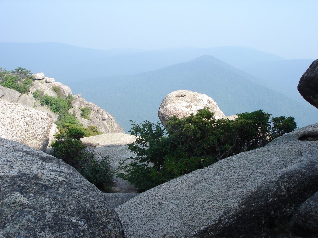
Within a few minutes, the trees mostly disappeared except for wind-stunted rhododendron, Virginia pine, and gum trees. Ahead, lay an ominous ridge of three rocky knolls, poised like small steps to the summit- a mile of rocky hell.
For the next hour and a half, Sam and I pressed on a little at a time. I took frequent breaks to rest while Sam snapped pictures of the 360 degree views. The trail was marked with blue paint strokes on the rock surfaces. Sometimes the blue markers would point downward, left or right, through rock tunnels. Several times, I had to hoist myself up a sheer rock wall. Thankfully, I have excellent new hiking boots that allow me to make the tiniest rock edge into a foothold. There’s one spot where you have to wedge yourself sideways and down (the blue trail marker points down) about seven feet into a very narrow chute. From there, walking sideways, you have to move along fissure until it spills out onto a rock ledge. Then you have to teeter along the edge until you make it around a dangerously high corner. Later in the scramble, we except this one went steeply uphill. About halfway along the crawling corridor a huge boulder rests seemingly magically perfectly in the chasm. Apparently an eon ago, the boulder fell into this crack but got wedged just before it hit bottom. Hence, by crawling on your stomach for a few yards, you can wiggle under it to get to the rest of the fissure. The coolest place on the trail might be were you make a right turn from a relatively normal scramble and walk right in to a natural tunnel. There is just enough room to scrunch down and walked stooped over as you bob and weave to the other side. The temperature in that tunnel was really pleasing an a steamy morning.
Eventually, we made the summit; I was very out of breath and exhausted but proud that I could still make the climb ten years after my last visit. Up on top, you could wander around boulders that giants had obviously had fun tossing around. Clambering over and around each rock offered a new vista into the sweet Virginia haze. You could almost see the highest peaks in the Shenandoah about ten miles away, Hawksbill Mountain, Stony Man Mountain, and others. Looking south and east, your eye could range over and past Syria and Banco, past Doubletop Mountain and Graves Mountain. Trying to slice your view through the haze to Wolftown was nigh on impossible.
Relaxing at the summit, we found pools of life. Sam discovered pot holes bored into the solid granite in places. These holes, drilled over thousands of geological eras and filled with brackish looking water, harbored colonies of creatures. Hoards of insect nymphs swam in chorus around these tiniest of ponds. Tiny tadpoles occupied the top rung in the food chain in these spas, scrounging for tasty treats. Thousands of the smallest tadpoles, just out of the egg waited to be picked-off by drive-by predators.
We reluctantly left the gentle shady breezes of that glorious mountaintop and descended by way of the steep longer trail to the Weakley Hollow fire road. Along the way, we passed Byrd’s Nest # 2 shelter and Old Rag shelter. These two structures, built in a stranger time when politics swirled around the park and families were hustled out of their homes to make way for the progress of a new outdoor recreation area for the well-heeled in Washington, are made of solid mountain stone, the most abundant natural material in the area. Reports from the late 1920’s documented the many travels of Governor Harry Flood Byrd, the ruler of Virginia, through the Old Rag area from Skyland at the top of the park to Old Rag below.
The walk along the Weakley Hollow Fire Road was rather mundane except for the lush scenery. I’ve read posts on other internet sites that claim the walk along this road is boring. I beg to differ. Although the hike is relatively flat, it is rich in foliage and history. All along the path, a person can visualize the trauma people suffered when they were evacuated from the park in the early 1930’s. Still to this day, remnants of those early homesteads survive. Additionally, we encountered park service road crews with bulldozers many miles from civilization. Most incredibly, we saw packs of tiger swallowtail butterflies as they clustered on the artificial shore of the Rose River near the parking area.
Old Rag Mountain and the surrounding area are rich in history and in scenery. Hopefully, I can bring the readers some of the history in future installments on this blog.
No comments:
Post a Comment